This site is currently under development.
Skip to content --- cover-image: https://raw.githubusercontent.com/GTIF-Austria/public-narratives/refs/heads/main/assets/nvisionpublic/nvision-green-roofs-cover.webp 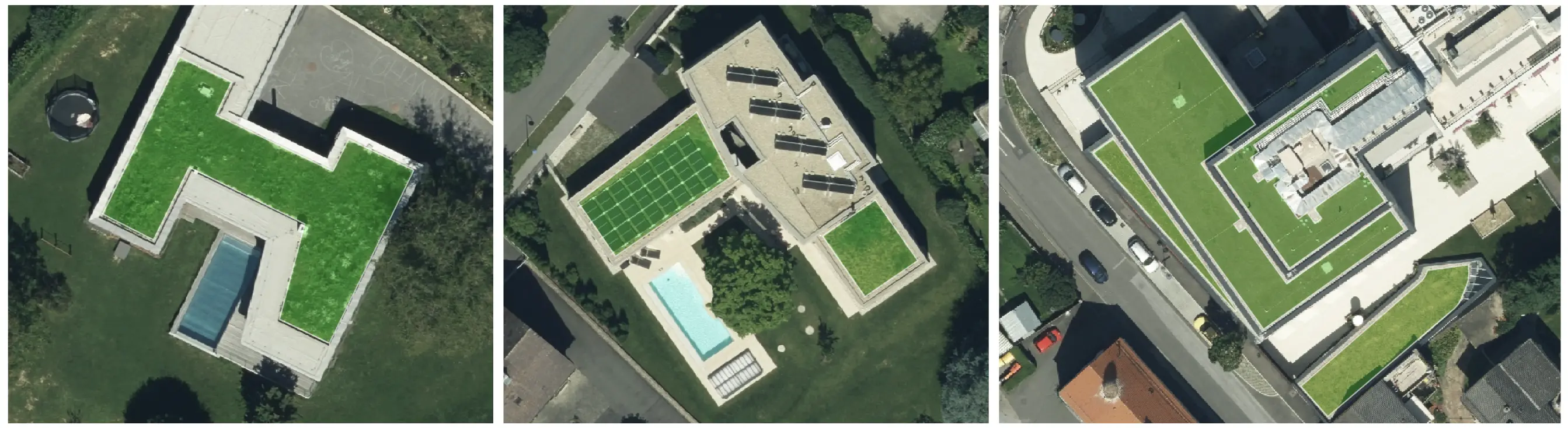
domain: Sustainable Cities tags: remote sensing, computer vision, city planning provider: N Vision
Green Roof Mapping
This service provides high-quality insights about existing green roofs in areas of interest by analysing satellite or aerial imagery using state-of-the-art computer vision methods.
Features
- High-quality: Powered by the latest generation of AI-technology, the provided solution by N Vision enables automatic mapping of existing green roofs at very high accuracy.
- Quality Assurance: In case of remaining failures, human validation is performed to ensure high-quality data across the region of interest.
- Up-to-Date: By capturing and analyzing recent imagery, the extracted data represents the status-quo of existing green roofs.
- Monitoring: Ortho imagery captured at different time intervals can be analyzed to measure changes over time.
- Cost & Time Efficient: This approach is up to 6x more cost and time efficient compared to traditional approaches.
- Fast & Scalable: Large datasets are handled efficiently, making it ideal for projects of any size.
Product Description
The Green Roof Mapping solution provided by N Vision gives precise and up-to-date insights on green roof locations, coverage, and impact in urban environments. Using AI-based computer vision algorithms and high-resolution aerial or satellite imagery, this service delivers precise and actionable data.
Designed for city planners, environmental agencies, architects, and researchers, this solution provides data about existing green roofs to support building sustainable and climate resilience cities.
Accuracy
For mapped green roofs, N Vision aims to achieve 95% or higher in both precision and recall. Efficient data validation workflows are embedded to ensure high quality data.
Add-Ons
Optionally, green roofs' vitality can be assessed by analysing multispectral bands. In addition, the emitted temperatures of green roofs can be measured by merging the results with thermal data.
Deliverables
Customers will receive the full set of mapped green roofs and belonging attributes. Further, a report with insightful KPIs of the extracted data is provided.
Data Access
The extracted data will be shared in standard GIS files (e.g. Geopackage or GeoJSON). Additionally, the data can be fetched from N Vision's API to automatically integrate the results into workflows.
Disclaimer
Due to the nature of using ortho imagery, only green roofs which are visible in the images can be extracted. The accuracy of mapped green roofs depends on the quality of the source imagery. The higher the quality and resolution of the images, the higher the accuracy of the extracted data. During manual validation, no onside validation is performed. Validation is performed using ortho-imagery only.
Pricing
N Vision's goal is to provide fair offers which are tailored to customer’s specific needs. In order to get a customized quote, please reach out to Gerhard Neuhold (contact details below).
Ortho Imagery
If no recent ortho imagery is available for the areas of interest, N Vision supports acquiring required datasets.
Free Samples and Demos
N Vision provides free sample datasets and demos of the provided solution. An interactive demo to showcase the quality of mapped green roofs can be found here.
Contact
For any question, or discussion about specific needs or problems, do not hesitate to get in touch.
Gerhard Neuhold
CEO & Founder
gerhard@n-vision.at