This site is currently under development.
Skip to content --- cover-image: https://raw.githubusercontent.com/triebnigg/public-narratives/triebnigg/evapotranspiration-monitoring-2/assets/triebnigg/Windatlas-1749907861729.png
domain: Energy Transition tags: wind potential provider: Energiewerkstatt
Austrian Wind Atlas
Problem
Wind energy is an essential and indispensable part of the expansion of renewable energies in Austria, in particular as it complements energy production from photovoltaics and hydropower during the night and in the winter months. Since many of the areas ostensibly suitable for wind energy are already being used intensively (e.g. in northern Burgenland or Weinviertel), the challenge in the further expansion of wind energy increasingly lies in the identification of further suitable areas. The most important criterion for the identification of such areas are suitable wind conditions at the hub height of wind turbines, at about 100 to 200 m above ground. Without dedicated measurements or prior experience on site, the wind conditions at such heights are not easily assessable. Therefore, dedicated datasets on the wind conditions at hub height (“wind atlases”) are an important basis for the estimation of wind energy potentials and the identification of suitable areas for wind energy development.
Aim
The last comprehensive assessment of wind potential in Austria was carried out in the AuWiPot study in 2011. The aim of this service is to provide an update to this dataset to interested stakeholders. This in particular includes:
- greater hub heights
- high resolution data for wind power density in different heights above ground
- provision of wind power density as an on-demand service That way, this service as part of GTIF-AT C shall be a suitable data basis to support the political process of the designation of RED-III areas [^1].
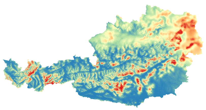
As an example for one type of information provided by the intended service, this figure shows the mean wind power density from AuWiPot at 100m above ground ranging from 20 W/m² (blue) to 400 W/m² (red). [^1]: RED III acceleration areas (also known as "renewables acceleration areas") are specific land or sea locations designated by EU Member States where the deployment of renewable energy projects is fast-tracked through simplified permitting processes and exempted from individual environmental impact assessments, provided they meet certain criteria. You can find the formal definition and detailed framework in Article 15c of the Renewable Energy Directive (EU) 2023/2413
Method
The main tool for the creation of the Austrian wind atlas is a geo-statistical model for the calibration and sub-grid scaling of numerical weather models using high resolution geographical data and terrain roughness. This process involves the following steps:
- Preparation of meteorological weather models as input data sets.
- Calibration, testing, and validation of the geo-statistical model.
- Application of the geo-statistical coefficients and wind shear profiles to obtain Austria-wide dataset for the wind conditions in different heights above ground (wind atlas). The method employed in the calculation of the data for the Austrian wind atlas can be applied to other countries or regions. It is thus planned to provide this algorithm via ESA's network of resources and transferability of the algorithm is considered in the implementation of the method.
Long Term Perspective
After completion of the ESA contact in early 2026, a handover of the results and services into governance by Austrian stakeholders and into sustainable operation is scheduled to take place. The scope of this service is aligned to the requirements of the Austrian stakeholders and the suitable POCs have been nominated to ensure an ongoing input as to the relevant needs and priorities. Austrian stakeholders should thus have a strong interest in the continued availability and maintenance of the results, which will very much help in funding a continued operation. Stakeholders include local authorities (federal, state), districts, regions, wind farm planners and operators.
Contact:
Alexander Stökl - Energiewerkstatt